30 November 2008
Image: Orongo Volcano. This shot was taken by Pete Polsgrove in August 2008. I did not have my camera on this run, so I had to dig into my Rapa Nui photo archives.
Today was a really great day. Initially, we had planned to go surfing this morning. However, when we arrived at the beach, there were no waves. So, we decided to go for a run. After stopping by Alicia’s house and my hotel room to grab our gear, we ventured to the base of Orongo. Orongo (or Rano Kau) is the second largest volcano one the island. Our plan to run up and then down the volcano. It was high noon and near 100% humidity at this point. It was rather funny. As I am running up this volcano, I’m thinking this is not the right time of day for this, and about that time, Alicia’s said, “we should be doing this at six or eight in the morning." We both laughed and proceeded up hill.
This caldera of Rano Kau is absolutely breathtaking. There are literally a hundred freshwater lakes within this caldera. You can also peer through the lowest point of the caldera and into the Pacific Ocean.
Image: Another view of Orongo. Credit: Pete Polsgrove.
After gazing into the volcano for sometime, we decided to tackle the down hill portion of our run. This was a blast for me. I haven’t ran down hill in a while, and I was really looking forward to opening up the legs and running hard. Once we were back to the jeep, Alicia said I usually jump into the ocean after this run. Looking around and noticing there were only cliff faces to be found, I agreed that a dip in the ocean would be great!
So, we walked down to the water and we jumped off a 30 foot cliff into the ocean. It was an amazing adrenalin rush.
Thereafter, we grabbed some lunch and then off to the caves. We had another day in the Maunga Hiva Hiva region.
There were a few leads that we discovered yesterday, that we wanted to pursue. However, we wanted to check out the tourist cave first. There is a large tourist cave in this region that I wanted to inspect. I determined this would be a good cave for biodiversity inventories because it has received so much human visitation. This cave has two major sections, one is northward toward the coast, the other southward. We went through the northern section first. There were some other leads near the coast that we wanted to inspect. The northern section is highly disturbed and the soil of the cave floor is highly compacted. I would be surprised if much life exists in this cave.
Image: Alicia Ika.
Once we arrived at the northern most entrance, we walked further northward to some large guava trees. This was good for two reasons – one fresh guavas, two it was a collapse pit with a cave within. After completely gorging ourselves on ripe guavas, and debating about exactly how many guavas does one need to eat to get really sick, we decided to go into the cave. This cave has been highly modified and extensively used by ranchers. The locals had pumped water out of this cave and filled two troughs for horses – one was within the collapse pit, the other was on the rim of the pit.
Interestingly, this cave contained millipedes, spring tails and nematodes. We will be coming back to collect at this cave in a few days.
Once done, we returned to the tourist cave. We wanted to explore the southern extent of the cave. This section contains an avocado tree that had grown up out of a sky light. It had fought for every ray of sunlight for many, many years before growing about 20 feet high and breaching the surface through the cave. Once we arrived at the tree, Alicia and I decided to climb it to get out. This was a lot of fun and a little challenging as well.
Image: A majestic veiw from one of the many cliff caves we investigated during this expedition.
26 January 2009
My Return to Rapa Nui
28 November 2008
Image: The horses of Rapa Nui.
My plans for this week long trip will be to meet with my friend Sergio Rapa to discuss developing a proposal to continue the work here. I also hope to me with the Governor of the Island, as well as representatives from CONAF and the Museum. I want to start the process of applying for research permits, as well as get all the other details dialed in for this work.
Sergio, my good friend, as well as my colleague in a proposal to study the cave archaeology and biodiversity of the island, was unable to pick me up at the airport. He had meetings that had delayed him from picking me up.
Fortunately, I was met by another good friend of mine, Alicia Ika. She and a friend of hers, Jenny, came to the airport to welcome me back to Rapa Nui. And in the Polynesian tradition, Alicia gave me a flower lei, as well as a ride to Sergio’s hotel. Alicia and I will be working together in the island the entire week.
Once at the hotel, I awaited Sergio’s arrival. Sergio leaves for Santiago tomorrow; he and I need to discuss our proposal before he departs. We decided to meet tonight to discuss the proposal.
I then gave Alicia a call to set up our plans for the week. Interestingly, the hotel phone does not permit you to call to a cell phone. So, I had to go to a tattoo parlor, that also happened to serve as a central telephone facility – here I can make calls to a cell phone. After trying to speak with her for about 20 minutes and dealing with a horrible connection, she invited me over to her house to chat in person.
Alicia, her Mom, and Jenny had just completed a large fish lunch and a nap. Upon my arrival, Jenny told me they had left-overs, and she asked if I was hungry. Knowing that I was going to eat fresh fish, my answer was a resounding “yes!”
I then proceeded to stuff myself on a large plate of fresh fish and potatoes. While eating, Jenny was playing Elvis, and she was telling me how much she liked his music. By this time, another one of Alicia’s friends arrived at her house. We then decided to go down to shore. We went to Ahu Vinapu -- a Moai site characterized by the most impressive stone Ahu on the island. This Ahu is comprised of large basalt monoliths puzzled together in sheer perfection. Some of the contact points where stone is pieced together is so tight, one cannot slip a piece of paper between the two stones.
I marveled at this structure and the toppled Ahu for some time. Then, Alicia and I down-climbed the cliff face to the water. We went down to the shore to collect water-worn rocks for Alicia’s garden. We spent some time walking along the shore.
She observed an outcrop of yellow soil, which she indicated is of the correct consistency for making body paint for ceremonies. However, we were unsuccessful at finding a safe route to this outcrop. We determined the best way to do this would be to rappel down from the edge of the cliff. We want to do this on this trip, but it may have to wait until I return in June.
After our little outing, we dropped off my new friends, I went back to Alicia’s house, grabbed her motorcycle and then she gave me a ride back to the hotel.
Jut and the Volcano
Originally drafted 20 November 2008
Image: Sun rise at mid-camp. Credit: Cristian Tambley.
This was an incredible challenge for me. I loved it! It's a lot like when I'm doing a long race. The ego takes over and you start to think, "what the heck am I doing here?" But then you realize exactly what you are doing. You reel in the ego, concentrate and realize that you are pushing yourself in ways that strengthen no only the mind but the body as well. I was completely alive and intimately familiar with every step that I took.
Image: Mid-camp (16,500ft) on the slopes of Volcan Simbad.
The cough was kicking me in the rear end, but I knew that I had a job to do once I reached the summit. And, I knew that I would reach the summit. Claudia, our expedition doctor, told me that altitude diminishes ones immune system, and that high elevations also tend to spur a cough in most. Because I had been sick most of the expedition, and I was at high altitude, this cough really had a hold on me. However, I did not realize how troubling it was until the second half of the climb.
The first half of the climb was quite easy. I've done once already and I knew what to expect. However, when we ascended we were carrying more weight than we did on our training day, but we were all still strong and climbing well.
Image: Having breakfast before our summit attempt on Simbad. Left to right -- me, Ingrid and Kevin. Credit: Cristian Tambley.
We spent the night at mid-camp, which is around 16,500ft elevation. I was feeling the effects of altitude here. After being at mid-camp for a few hours, I realized how winded I was if I simply walked from one end of camp to the other. The entire team ate early, and we called it an early night.
Image: Our ascent to the summit. Ingrid is at right. Yes, I'm the only one on the team with a light on his helmet. In my defense (though it may not be much of one), I leave for Rapa Nui to continue my cave work -- so, I brought my caving helmet.
I went to bed around 2000hr, but I only slept about three hours that night. For the first few hours, I found it very difficult to breath. I placed one of my backpacks underneath my head in an attempt to elevate my chest. This helped a little. Then, my tent mate, Nathalie, suggested opening one of the tent’s vents. I believe a combination between the two enabled me to breath much better. I was then able to drift in and out of sleep for the next several hours.
Between really weird high-altitude dreams and my inability to breath, I woke up the next morning ready to tackle the volcano. However, my cough had not abated. So, I had to make the ascent with a cough.
The second pitch – The climb for me was slow and steady for the most part.
Each time I stopped, I was coughing up a lung. I placed a bandanna over my face so that the air I was inhaling was slightly warmed. It seemed to help a little.
It’s funny; when you are standing at the base of Aguas Calientes, it does not appear that big. When you’re climbing though, you know she is a behemoth.
It was quite a sense of accomplishment once we reached the summit. I’ve never been to 19000ft, and the views were absolutely spectacular. Oddly enough, I didn’t notice the lack of oxygen as much while climbing and while on the summit. The lake was absolutely beautiful. It was pinkish red. We still don’t know why the lake is that color, but several on the team are investigating this question.
Image: The view of Simbad's caldera. Kevin, Jeremy and others are studying this lake to determine why the water is red. Credit: Cristian Tambley.
Once on the summit, I actually jogged around a bit, and got in trouble by the expedition doc. I’ve ran at 14K, but never 19K. However, I felt fine after my little job and was barely winded.
Unfortunately, I did not get to map the lake using the bathometry unit. The lake was frozen. However, we did set up the dosimeter (UV meter). It is currently collecting data at 19,000ft.
All and all, this was an incredible experience and expedition. With each expedition I complete, I walk away a better and more knowledgeable person. Expeditions truly can help one grow.
Image: Cristian and I sitting proudly before the dosimeter. This UV instrument is currently logging data at 19,000ft!
Training day – The Climb to Mid-camp Volcan Aguas Calientes
Originally Drafted 16 November 2008
Image: The team on the ascent up the volcano.
Today, we train. We will be making our ascent to 16,500ft. This will be the highest I've been to date!
Image: Our ascent leader, Macario. Credit: Cristian Tambley.
The ascent team will be led by Macario, a 62 year old Bolivian, who has worked with Nathalie for almost a decade now. Macario is definately one of my heros. When we made the ascent to 16,500 ft as part of our training, I realized Macario has made the ascent to the top of the volcano four times this week! I hope that if I reach 62, I can still be able to climb 19ers!
Today, I felt strong and I realized that I would be fine making this climb to mid-camp. However, my cough has not gone away. As I was climbing, I had to use a bandana to cover my mouth so I could breath in warmer air. The rational was that the air would be a bit warmer and would not be such a shock to my lungs. Well, I reckon it kind of worked.
All and all, I climbed strong and I felt good. I have done many endurance races in the past, and I realize all I have to do is get myself in race mode and I will be fine. In 2007, I completed the Mount Taylor Quadrathlon when I was near hypothermic during the downhill ski portion of the race.
So, while I realize climbing above 16,500ft will be challenging, I am confident that I will summit in a couple of days.
Image: Standing at 16,500ft on the slope of Volcan Aguas Calientes (also known by the Quechuan people as Simbad).
Laguna Aguas Calientes
Originally Drafted 13 November 2008
Image: We arrived on the altiplano right after the nandu breeding season. We observed countless nandus with chicks. This is one of those precious shots. Credit: Ingrid Peate.
Today, we went to Laguna Aguas Calientes. For all the lower elevation work, I'm the multi-parameter water chemistry guy. I walk around with this incredibly slick and expensive instrument. I see how dirty i can get it and I continue to push it's functional capabilities to the limits. The second day in the field the pH meter on this unit failed. So, I'm now calling into question the accuracy of the other sensors. Fortunately, we are collected water samples and water chemistry analysis will be repeated in the lab. So, if there are problems with the data collected, we have a back up.
I don't have a lot to report here, but I do have some great images of the area.
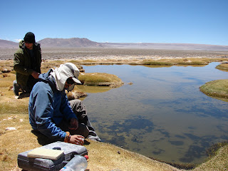
Image: Eric Fleming background and Eric Pinto foreground. We're setting up to start data collection at numerous spring-fed pools along the outer edge of Laguna Aguas Calientes.
Image: While it may look like I'm getting ready to take a nap. I'm actually collecting data on this pools water chemistry.
Image: A view of the freshwater ponds adjacent Laguna Aguas Calientes. In the not too distant geological past, these small ponds were likely part of the Laguna; as the Laguna receded, these spring-fed pools have become isolated.
It makes me wonder what interesting arthropod communities are waiting to be studied right here where we sit? How may new species are beneath my feet?
The Howling High Winds
Originally Drafted 12 November 2008
Image: Team members on Laguna Lejia. Credit: Eric Fleming.
It was another cold night at Chillyfornia. Fortunately, my -15° sleeping bag kept me nice and cozy. I actually broke a sweat this morning, and I had to shed a layer to continue my slumber.
We returned to Laguna Lejia again today. I had quite a treat as we were making our approach into the Laguna basin, we spooked a herd of vacunas, and they took off across the plain. They kicked up quite a bit of dust in the process, and I just sat and watched in awe. This is a desolate, yet truly amazing place.
As is per usual up here, the winds were howling on the Altiplano. So, it's going to make for another fun day up here.
My objectives were to collect water habitat information (using our multi-parameter instrument) related to the Laguna proper and assist Nathalie and Eric Pinto in collecting water samples. Eric Pinto is a graduate student at UCN-Antofagasta. He is collecting water samples of all the small ponds, as well as the lake. These samples will be studied in the lab.
I arrived early with the first group of researchers. So, before I started my work, I volunteered to assist Kevin Rose and Jeremy Mack in collecting a UV profile of the lake. These researchers are studying the copepods that occur in the lake and the smaller ponds. They are investigating the relationships between UV and their life cycle. So, we trudged about 30 meters into the laguna and through the sinking mud to operate this instrument.
Image: Jeremy and Kevin heading into Laguna Lejia with the UV meter. Image: Eric Fleming.
As we were wrapping up this data collect, Nathalie, Eric Pinto and the others arrived. So, I went off to work with Nathalie and Eric. Nathalie has been ill the past couple of days, and she decided to return to camp to rest.
So, Eric Pinto and I collected water samples and I continued to collect water chemistry data. Nothing overly exciting and in the eyes of the common observer, it was rather mundane data collection. However, we were doing it at 14,000ft on the Chilean Altiplano!
Once the data was collected, we were done for the day. Everyone remaining on the Laguna was now ready to head back to base camp.
Our resident geologist was still working along the southern shore of the lake. I decided to remain with her so she could complete her work there. Once done, we were done for the day. We packed it up and headed back to Chillyfornia!
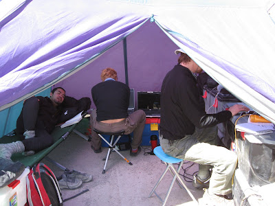
Image: Back at Base Camp. Featured in the office/ medical tent from left to right Eric Pinto, Claudia and me. Image: Cristian Tambley.
Rejoining the High Lakes Expedition Team
Originally drafted on 11 November 2008
Image: Chillyfornia base camp. Located at 14,000ft in the Chilean Altiplano.
Unfortunately, due to research permit problems in Bolivia, and Nathalie made the call to pull the plug. The entire time returned to Chile on 09 November. I arrived at “Chillyfornia” on the night of 10 November. Chillyfornia is an abandoned military barracks that provides us with four walls to partially shield us from the high Altiplanic winds.
Apparently, I brought the cold air with me. I was told tonight was the coldest night to date. It was around 20 below zero last night! Good thing I had my brand new Mountain Hardware -15 bag. This isn’t a shameless plug here; the -15 degree Lyell is bomber! I was snug as a bug in a rug!
Image: This is Lazcar. This active volcano actually erupted while the 2007 High Lakes Team was reaching the summit of Simbad. Lazcar is just a few miles away.
Today was my first day of fieldwork on the High Lakes Project. I still have a hacking cough, but after lying in the bed for the past several days, and watching more American television than I normally do at home, I was eager to get into the field.
I was working with Nathalie and Eric Fleming. Eric is a postdoc and microbiologist with NASA Ames; he is investigating the diatom communities living in the small pools along Laguna Lejia.
This large lake is situated at 14,000 ft, and laid within a valley. It was absolutely astounding. Lazcar, the only active volcano in the region, blew steam the entire time we were in the field. A dormant sister volcano, Simbad (or Aguas Caliente) rises slightly above Lazcar to the south and west. Flamingos fed on copepods along the shoreline. It is an absolutely amazing place.
Image: This morning as we drove across the Altiplano we encountered nandus (Rhea pennata). These large flightless birds belong to the ostrich family but are much smaller, and have been commonly observed out here.
Our objective for the day is to use the multi-parameter tool, which is essentially a water chemistry lab in a box, to collect data along an inner tidal pool that is partially fed by Laguna Lejia. While Nathalie and I did this, Eric was collect microbial mat samples at each sample location.
It is also possible this tidal pool is spring fed; however, we have yet to confirm this. It may be somewhat of a misnomer to refer to these features as tide pools. They are pools which were likely part of the lake and when it receded, these pools have become isolated from the lake.
Nathalie and I were operating our new multiparameter instrument, which collected several parameters related to the aqueous habitat. These parameters include temperature, pH, conductivity, resistivity, ORP, salinity, and total dissolved solids.
Image: The view looking out the door of our four walls at Chillyfornia. Credit: Cristian Tambley.
Subscribe to:
Posts (Atom)